Virginiae Item Et Floridae Americae Provinciarum, nova Descriptio
Cartographer Gerard Mercator
Engraver Jodocus Hondius
From Gerard Mercator’s
Atlas…auctus ac illustratus a Iudoc Hondio.c. 1606
Amsterdam
Copperplate engraving
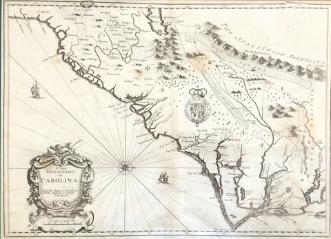
This map is based largely on John White’s 1590 map of Virginia and
Jacques le Moyne’s 1591 map of Florida. The Mercator/Hondius became the most important regional map of its time being closely followed cartographically for nearly 70 years after its initial printing. It also played a large role in helping a group of Englishmen establish what is arguably the most important colonization in North American history, Jamestown, Virginia.
Hondius borrowed numerous depictions from White, often using the same nomenclature. Chesepioock sinus depicts what is today’s Chesapeake Bay. Roanoac depicts Roanoke Island (island of the inception and disappearance of Sir Walter Raleigh’s Lost Colony), and Wokokon evolved into Ocracoke Inlet, albeit slightly displaced.
Geographical and topographical misconceptions abound throughout the map. For instance, the waterfall depicted in the Apalacty (Appalachian Mountains) is thought to be Niagara Falls by today’s historians. The large lake shown just below that is based partly on Indian myth and the early depiction of the Okefenokee Swamp. St. Augustine is erroneously placed on the coast which gives the illusion of a compact coastline for today’s South Carolina and Georgia.
Embellished with various game, ocean vessels, sea monsters and Indian villages, it is considered to be “one of the most beautifully executed maps ever of the Southeast.”
reproduced from The Mapmaker’s Art: The Bishop Collection of Antique Maps from the permanent collection of the Franklin G. Burroughs-Simeon B. Chapin Art Museum
printed by 803 Labs, Inc.
*Pricing Does Not Include Shipping | Call the Museum for Shipping Cost