Partie Meridionale de la Louisiane avec la Floride, la Caroline et la Virginie
Jean Baptiste Bourguigonon D’Anvilee
1776
Venice
Published by P. Santini
Copperplate engraving, outline color
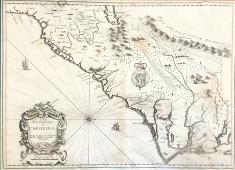
Scaled in Italian and English miles, this interesting map of the southern
area of America published during the Revolution depicts Florida rather
oddly-shaped and shows no boundaries between the Carolinas.
Various Indian tribes are located, among them the “Cherakis” and the “Catawbas.” Note the “Waggomau” river and the fact that the location for the towns of “Kingston” and Queensborough” has been mistakenly switched.
The map also shows the Savannah River in South Carolina rather than as the border between South Carolina and Georgia.
reproduced from The Mapmaker’s Art: The Bishop Collection of Antique Maps from the permanent collection of the Franklin G. Burroughs-Simeon B. Chapin Art Museum
printed by 803 Labs, Inc.
*Pricing Does Not Include Shipping | Call the Museum for Shipping Cost